


Poster Estate Map - Croydon Park Stanley Bridge Estate, Norman Park
Library Shop
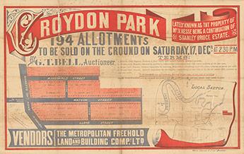
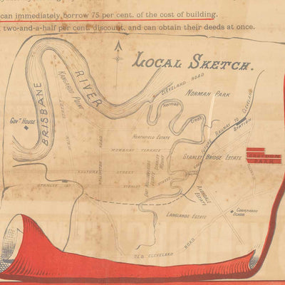
This real estate map from 1887 advertises 194 allotments of land for sale at the Croydon Park Estate, which is today part of the Brisbane suburbs of Norman Park and Camp Hill. The allotments were situated on Bennetts Road, Lloyd Street, Watson Street, MacDonald Street and two unnamed lanes (now Wimbledon Street and Garsdale Street). Croydon Park Stanley Bridge Estate, Norman Park 194 allotments to be sold on the ground on Saturday 17th December by G.T. Bell, Auctioneer. Estate covers area now in Norman Park and Camp Hill.
We leave a small white border of 10-15mm around the image area to protect it during shipping, to avoid fingerprints while being handled, and to allow for framing (prints do not come framed).
Prints will be carefully rolled and mailed in a protective tube.
Aside from a small selection in-store, all prints are print on demand. Please allow up to 48 hours for production.
ISBN: PODMA134
Format: Print Art
Dimension: 590mm X 370mm
Print details
37cm x 59cm approx size. Prints are created using archival pigment inks on A2 size 200 gsm archival photo paper with a matte finish.We leave a small white border of 10-15mm around the image area to protect it during shipping, to avoid fingerprints while being handled, and to allow for framing (prints do not come framed).
Prints will be carefully rolled and mailed in a protective tube.
Aside from a small selection in-store, all prints are print on demand. Please allow up to 48 hours for production.
ISBN: PODMA134
Format: Print Art
Dimension: 590mm X 370mm